Monday, October 31, 2016

Coffeeneuring 2016, #4: Home Coffee Shop

Ride: 4

#4: Home Coffee Shop at Susan's

Date: October 29
Destination: Susan's house
Beverage: Coffee mit Schlag and Pumpkin Pie, also mit Schlag
Bike Friendliness: garage
Bicycle: Rivendell Bleriot
Total mileage: 20+ miles

Susan baked a pumpkin pie and opened up a Home Coffee Shop so she'd have help eating it.  I was the only one to show; more pie for meeeeeeeeeee!

Riding to Susan's is fairly straightforward; most of the route was my commute for a year or so.  The only challenge was that I won't ride on Evergreen through the shopping center, and had to cut north from Cornell, but not too late, or I'd miss the turnoff on the Rock Creek Trail.

While cloudy, it did not rain.  Susan, Jeff and I sat around, visited and ate a lot of pie.  She also sent me home with a piece for Fitz.

Pretty fall colors.

#4: Home Coffee Shop at Susan's

#4: Home Coffee Shop at Susan's

#4: Home Coffee Shop at Susan's

#4: Home Coffee Shop at Susan's


Coffeeneuring 2016, Rides 1-3

First question, do I have a theme?  I'll just say I have one in mind, and am choosing my destinations accordingly.  But it is sort of like an R-12 or P-12, where you don't out yourself, until it is well underway :-)

So, rides 1-3:

Ride: 1

Coffeeneur #1

Date: October 7
Destination: Solace Coffee, Beaverton, OR
Beverage: Peppermint Mocha
Bike Friendliness: wave rack
Bicycle: Rivendell Bleriot
Total mileage: 3.2 miles
I had never been there, so I thought I'd check it out.  It is in a strip mall with many expedient food eateries, and right across the parking lot from the Beaverton Police Department.  I still locked my bike. :-)  There are many chairs and tables, books, magazines and toys trains.

Ride: 2

Coffeeneur #2: hanging at the weaving studio

#3: Grand Central Bakery

Date: October 18
Destination: Grand Central Bakery, Multnomah Village, Portland, OR
Beverage/Food: Coffee and a chocolate croissant
Bike Friendliness: wave rack
Bicycle: Rivendell Bleriot
Total mileage: 13+ miles

I have a Beginning Floor Loom Weaving class in Multnomah Village every Thursday morning.  I arrived with coffee, and threaded the heddles and the reed (this is part of "dressing" the loom before doing any actual weaving).  After class I dropped down the hill and paused at Grand Central Bakery for coffee and a croissant.  While I have been there via bicycle several times (our Solstice Perm started there), I have never coffeeneured there.  While I had only a croissant this time, their sandwiches are quite good.

The route from my house is rather fun - after dropping down my hill and crossing a couple of major streets, I ride quieter streets and the eastern section of the Fanno Creek Trail all the way to Garden Home, then ride up Multnomah Blvd, finishing with a one block steep pitch up to Capitol Hwy to the Arts Center.  Grand Central is just below the Arts Center on Multnomah.

Ride: 3

The ride start, and Coffeeneur #3

Date: October 24
DestinationFix Coffeehouse, Green Lake, Seattle
Beverage/Food: Coffee and a breakfast sandwich
Bike Friendliness: staple rack
Bicycle: Sweetpea
Total mileage: 2.1 miles

This one snuck up on me.  I was in Seattle to participate in the Dart Populaire, and stayed at a friend's house near our route start.  I had planned to arrive early enough to get breakfast and coffee before the ride, which I did.  That breakfast sandwich kept me going for quite some time.  I didn't realize I had coffeeneured until that evening!


Monday, October 24, 2016

An Unlikely Dart Populaire Team

Hares and Tortoise.  I was wanting to ride the Seattle Randonneurs Dart Populaire, which was going to be held the day after the annual meeting.  As I am in Portland and don't know the Seattle area well, I was hoping to get on a team formed up there.  Theo (the organizer) and I chatted, and he said he'd check around.

A week later I received an email asking if I wanted to join him and James.  He promised minimal distance and as few vertical feet as he could route to make it work.  I was in.

Then there were the Logistics - the route started in Green Lake and finished in Kirkland - 20 miles and a big lake in the middle.  The annual meeting was in Issaquah.  A kind randonneur who lives near Theo (and Green Lake) offered up a bed for the night, and Theo and I planned to drive over to Kirkland, leave my car parked by Mark's house (two blocks from the finish location), and ride over to Green Lake.

It was originally going to rain, and I packed for that.  After the car was loaded, Susan O shared an updated forecast with practically no rain.  I figured I'd check before leaving the car, and remove any superfluous rain gear before riding off east.  Theo also suggested I bring a u-lock.  I have one.  It must weigh at least two pounds.  But I brought it along.

After a delightful annual meeting (so nice to see everyone!), it got even better - Shan offered to drive Theo and me back into Seattle!

bikes on Shan's car

Theo and I arrived at Noel's house and let ourselves in, saying hi to the very large, very friendly dog.  We then hiked over a few blocks to get some dinner.  Thai, world's noisiest restaurant.  Food was good but there wasn't quite as much as I could have eaten.  I heard Theo had pizza with James later :-)  Theo pointed out the way I'd ride the next morning - I was under the impression that I'd just head down the hill, but I really needed to ride up a couple blocks and then down, so I'd end up in Green Lake and not Ballard.

Visited with Noel a bit and then conked out.  Up the next morning, organized, and out the door, but not before Noel told me to take a banana.  Fun ride up and over, and on the trail around Green Lake, where I quickly arrived at Fix Coffeehouse.

Our team had grown by one more - Audunn joined us.  Nice!

James at the start

The ride start, and Coffeeneur #3

We set out shortly after 8am.  While I had the cue sheet and the route loaded on my phone, I was just going to follow Theo.  Surface streets for a bit, then through Ravenna Park, which was firm pea gravel.  Theo: "homage to Ken M".  We then got onto the Burke-Gilman trail, familiar to me from several years of riding RSVP.  Susan O's team passed us, riding south.

I think we missed a turn somewhere :-( and had about 3 bonus miles added to fix that.  Then we were on the Bothell-Everett Highway for a good long while - strip malls and lots of traffic.  Better than some heavily-traveled suburban roads I ride here, but we were all happy to get to the end of that!  Lowell Larimer Road was a delight.  Peaceful and quiet.

Our first info control was at the corner of Lowell Larimer and Lenora roads, involving a house with a totem pole in the yard.

Untitled
Heading toward Snohomish; photo by Theo Roffe

We then turned east towards Snohomish and the delights of the Snohomish Bakery.  Food service was slow, so we all bought pastries and coffee.  Theo got a cheese bread thing the size of his head.

Theo at the Snohomish Bakery.

From there we headed north to Lake Stevens, by way of the Centennial Trail.  I am pleased to report that the Bollards of Death have been replaced with more standard bollards.  We saw both John Pearch and Ward Beebe out riding.  Arrived at the coffee stand in Lake Stevens.  Given that I was the slowest rider, I got my card signed and headed back; they'd catch up soon enough.

We headed back through Snohomish, and onto the part of the route that I recognized as RSVP in reverse.  So, up that hill on Springhetti, up Broadway (does this hill have a top?), arriving at the 6 hour control in Cathcart, perhaps a little past 6 hours :-)  Doesn't matter, you just can't LEAVE the 6 hour control before 6 hours.  There was another team sitting outside, snacking.

Bought a banana and some more water, and we headed out.  More miserably steep pitches (I never met a hill I couldn't walk up), and we finally arrived at the corner of Woodinville-Duval Road.  I was totally looking forward to the descent, but first offloaded my u-lock on Theo ("ooh!  More weight for the descent!  Yay!").  Oh that was fun!

We arrived in Wilmot Park, where there was discussion about the route, and how it wouldn't get us across the river and...  So, we went a slightly different way with a breathtaking wall which seemingly had no end.  I had to walk the whole thing, just couldn't ride up it.  I am still not sure which way we went.

Our 120km point was just as we got on the Kirkland Connector Trail, which we made by 7:50 elapsed.  So we rode on for another 10 minutes, then took pictures and signed each other's cards at the 8 hour point.

120km. Audunn, Theo, Lynne, and James

From there we had a leisurely cruise to the finish in Kirkland, at the Chainline Brewery.  I sat and drank a soda for awhile, and eventually scraped up the energy to get some tasty fries from the food truck.

Riders at the finish; Chainline Brewing in Kirkland

This was my first calendared RUSA ride since last November, and the most challenging ride I have done this year.  What with bonus miles and all, bike computer reports 79.6 miles, and 3154 vertical feet.


Saturday, September 10, 2016

A Longer Ride

It may be noticed that I am having some challenges in getting my conditioning and distance back.  Super frustrating, I must say.

So anyway, on Sunday, I asked Susan O if she wanted to ride one of the local 100k perm pop routes.  She instead offered up riding from their house out to Jeff's property in Willamina - 72+ miles, not very climby.  I'd finally get to see the property (I've been hearing about it for years), and Jeff would drive us all back in his Sprinter Van (now THERE'S a project), with a dinner stop.

Yes.  Sure. (No, not a RUSA-sanctioned route, but they don't all have to be!)  Fortunately, the bike was all back together; I filled some bottles, grabbed a sandwich out of the fridge and a few other food items, a change of clothes, and drove over to Susan's.

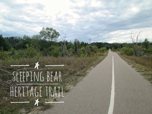
She was doing something with her bike, and then, a bit after 11am, we started out.  The route was roughly Hillsboro-Cornelius-Lafayette-Dayton-Sheridan-Willamina, and I am entirely clear on the obvious and common way to get there.

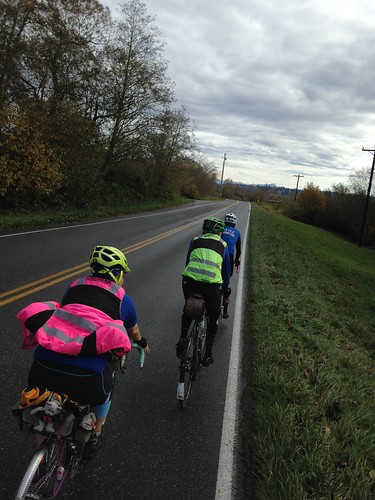
NotSoFast.  Susan had plotted a route that didn't quite do that.  The route through Hillsboro was mostly off the main streets, and very quiet.  We did have a stretch on TV Highway to Cornelius (at some point it just cannot be escaped).

I came up with a rear flat, of course, on TV Highway, when one cannot hear oneself even THINK.  I was carrying a spare tire, as I always do, so replaced the tire and tube.  Susan noted the extreme amount of wear on the discarded rear tire.  Oops.  Got my money's worth on that one.

Then another non-standard route through Cornelius, dropping us eventually on LaFollett, which then became the standard Geiger-Fern Hill (new chipseal)-Spring Hill-North Valley-Ribbon Ridge-Kuehne (where did all that traffic come from???)-Abbey(ditto) through Lafayette, thence to Dayton.

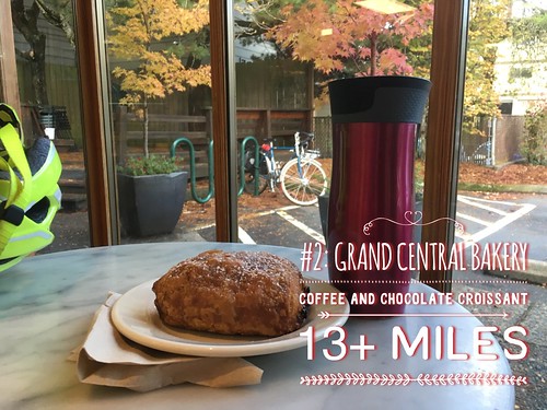
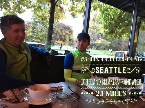
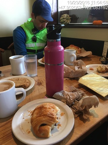
We discussed stopping in Dayton.  There is the Blockhouse Cafe, with same-day-service, but I knew that Susan wanted to finish before dark so she could show me around the property, and I also knew that she'd be getting there a lot quicker without me.  So I suggested the Center Market (prime randonneur stop), and we got more things to drink and eat.  I had a V-8 and a banana, and added a Kind Bar for later consumption.

Then we stopped and tweaked my seat adjustment.

Many years ago, Susan said that she was going to find a route between Dayton and Amity that didn't follow the infinity road ("Amity - 5 miles".  Further along: "Amity - 5 miles").  Well the new route gave Amity a miss altogether, but it was on blissfully smooth pavement (until DeJong Rd to Ballston Rd at the end), with no traffic whatsoever.  Nice scenery, too.  I think parts of it have been featured on the middle loop of the Grab Bag brevets.

My fender developed an annoying rattle.  It turned out both fenders had annoying rattles - the front had a bolt which needed tightening, the rear had rattled out the teeny little bolts on the L-bracket.  No way to fix that; I'd just live with it until I could get to a hardware store and buy more teeny little nuts and bolts.

So, after Dayton we just had scenery for miles and miles and miles.  Eventually we popped out in the former town of Ballston (General Store sign still there; building replaced with some metal garage-y thing), and Sheridan (last town before Willamina) wasn't TOO far away.

By now we were riding into a rather strong headwind.  The terrain wasn't particularly challenging, but the wind was not helping my forward motion.  I suppose I'd say that both the warp and impulse engines had malfunctions, and I just stopped and stood for a moment.  I could see the turn up ahead where we'd transition to a crosswind, but it took some effort to get there.

Susan was waiting, and told me that I'd ridden 100 km in 5:47 total elapsed time.  Given the past year, that wasn't bad at all.

Finally the turn, and a pretty special crosswind.  As I was descending into Sheridan, it took some effort to move forward in a straight line.

From Sheridan to Willamina, it was pretty much dead flat, wonderfully freshly paved, and rather more sheltered from the wind.

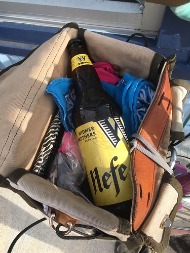
And finally there we were (although not quite finished).  We stopped in the "new" market in Willamina (there are now 4!), and perused the beer selection for a bottle for each of us.  Best I could find for me was a Widmer Hefeweizen, which isn't bad at all, there are just other beer styles I prefer more.

Stocking up in town

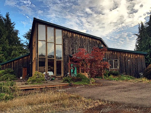
Now the last 3+ miles out to the property, gently rolling road (and more gloriously smooth pavement) past a lumber mill, and several farms.

I saw a sign up ahead that was probably a good indication of our turn, and indeed, Susan turned in.  At this point the driveway/road was gravel, but not bad at all.  We did walk the last pitch up; Jeff came out to greet us.

Destination.  Sweetpea and Thompson on the porch.

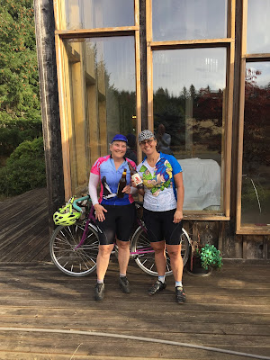
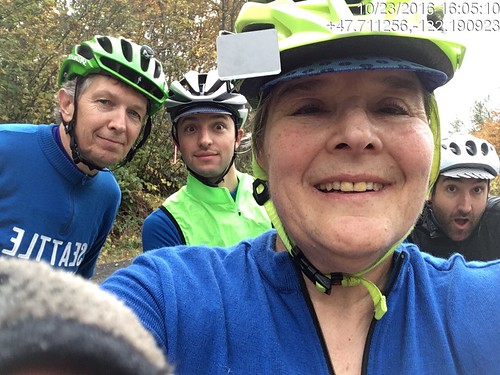
Susan and I, photo by Jeff (in the reflection!)

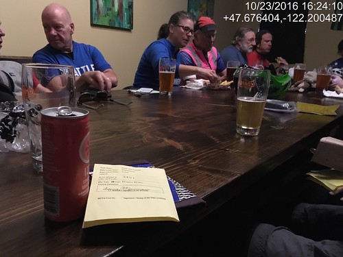
Dropped the bikes, opened the beers, and got a full tour.

Chair in the woods

Tuesday, August 30, 2016

My Details on the New Michigan Perm Pop

When I packed for the trip, I optimistically included cue sheets for both 1603 and 2390, as well as perm cards and a registration form.  All my riding this calendar year has been the North Plains Banks Vernonia Perm Pop, and not a whole lot of that.

So there we were, and I was looking at the perm pop and "nah, not this time.  Don't want to face those climbs..."

Revisiting the 200k (really 218k), I thought I might find a good 100k in there, to Glen Arbor and back.  And, pulling the route west between Empire and Glen Arbor, I was able to do just that, plus get to ride the brand new Sleeping Bear Heritage Trail.

Mapping out a route with RWGPS on an iPad is a little tricky.  And I couldn't download the cue sheet and edit it - I had to write it out and type it into Google Sheets.

Crista promptly approved the route.  Then the weather went slightly disagreeable for a few days.

When the weather improved, my husband basically ejected me out of the cottage and onto my bike.  He doesn't usually do that.

So I rode into town to the Crescent Bakery, and started the ride at 1pm.  Rode back out of town (brief pause to start RWGPS), then up and over Sutter Road (OMG the new pavement!), and points north.  It was all good until I passed the canoe outfitters at the Platte River (11.7 miles), and then entered into the "nothing to see here" for the next 11 miles to Empire.  Well, lots of trees.  Some cornfields. Climbing. Need to work on my mental state for that stretch.

After winching myself back out of Empire, turned onto M-109 and started looking for the Sleeping Bear Heritage Trail.  M-109 may be USBR-35, but it was also prime trailer and boat season.  Also, every camp and summer program in the area does a day trip to the dune climb, and M-109 is how one gets there.  The trail parallels the road, and I hopped on at Pierce Stocking Drive.  It was nice and shady, if a little bit more rolling that the road.

Rode by the Dune Climb, and was getting pretty excited about going through Glen Haven - it is a restored village with a General Store (no food/water), a Maritime Museum (the old Coast Guard station), a restored cannery, and other things.  Also nice clean bathrooms and water.

Moving along, the trail goes through a campsite and then the original routing had continuing straight on Pine Haven.  Nope.  Sand road.  The reroute goes right on Pine Haven, and returns to M-109 a long block or so sooner.

Glen Arbor doesn't really start until the intersection with M-22, so it seems like a longer ride into town than it is.

But anyway, I found myself some expedient ice cream, and sat outside the shop chatting with the proprietor.  Glen Arbor has many opportunities for food.

The return is a reverse of the route, and fairly uneventful.  I did stop in Empire for many things to drink, because it was humid.  I'd been drinking all afternoon, and needed more.  An older guy was returning empties, and the clerk asked for his birthday.  Something-something-1980.  I was looking at him thinking "wow, hard life."  The clerk was more forthright - "my son was born in 81, and you weren't born in 1980".  He finally coughed up a plausible birth year, finished his transaction and left.  The clerk and I looked at each other and cracked up.

Fitz was heading home from a golf outing, and passed me on the road just after the climb out of Empire.

More slogging along, although Empire to the Platte River is easier than the other way.  A pause on the Sutter Rd climb. A pause at the cottage to establish a meetup spot in town, and, finally the last couple of rollers (one pause) and done.

Stormcloud Brewing is my finish location of choice; they even have a cool rubber stamp, although if they are busy it might not be a good idea to send the bartender looking for it.

And hey, RWGPS in offline mode worked great!  Didn't hardly drain the battery at all!

Sunday, August 14, 2016

Permanent Populaire #3164: Frankfort - Sleeping Bear - Glen Arbor 102km

Sleeping Bear Dune Climb

Route
Cue sheet
Registration Form

Note: while I charge no fee for this perm, you MUST purchase a park pass to ride through the Sleeping Bear National Lakeshore.  The fee was $7.00 in 2016.

This route takes you from Frankfort, through the Sleeping Bear National Lakeshore, into Glen Arbor, and back again.

Starting at 4th and Main in Frankfort, your options for a control are Crescent Bakery, L'Chayim Delicatessen and maybe the coffee shop across the street whose name I do not remember.

Frittering (or more specifically Lemon Bismarcking) away the time before the start

You head east on Main Street, away from Lake Michigan, turn left onto 7th Street, which rapidly becomes M-22, heading north.

Three rollers out of town, and then you ride along Crystal Lake until the left turn onto Sutter Rd.  I am ever so pleased to report that Sutter Rd has been repaved!  It hasn't gotten any flatter, though.

The deer statues seen by the side of the road and in yards are not statues.  You might also spot a flock of wild turkeys.

At the end of Sutter Rd you turn left onto M-22 again, and there's minimal navigation for miles and miles and miles.  You'll pass the Platte Lake store (Riverside Canoe Trips, mi 11.7) if you need anything; there's nothing for the next 10 miles.  Well, lots of trees, as this is Up North.  Eventually the terrain starts rolling.

Heading north on M-22/USBR-35

When you see the Radome up ahead, Empire isn't far away.  You'll drop 200 feet into town.

The Empire Radome

Right at the intersection of M-22 and M-72 (traffic light), there is an EZ-Mart, which may be more interesting on your return.

But, more importantly, you can turn right onto M-72, go a block, and the Sleeping Bear Dunes National Lakeshore office on the left will sell you that park pass.

Continuing north on M-22, you'll climb up a bit, and then turn left onto M-109.

You'll see the Sleeping Bear Heritage Trail on your left, and you may prefer to cut over to it when you get a chance.  I hopped on at Pierce Stocking Drive.  There are driveways, and eventually, the Duneswood Resort.  It is a lot nicer riding on the trail - shaded and no RVs or pickups hauling boats!

If you did not get your park pass in Empire, you must buy one in the parking lot just past Hunter Rd, mi 27.3.

On your left is the famous Dune Climb, where people (mostly children) scramble up and down for hours.  There is also hiking at the top.  This is not to be confused with the EPIC dune climb at the end of the Pierce Stocking Drive, where the dune plunges precipitously down to Lake Michigan, and there are signs warning that you must pay for your own rescue if you can't climb back up.  Good times.

So, continuing along the Sleeping Bear Heritage Trail - there are a few steep bits, but they are all short - you'll eventually come to the first info control.  The sign is on the right, and it is the second sand turnaround.

Sleeping Bear Heritage Trail

By now the trees have receded into dune scrub foliage, and a mile or so later, you will arrive in the restored historic town of Glen Haven.  There's another info control here, or you can buy something in the General Store.  Note: they DO NOT sell anything to drink, but there is a water fountain outside, as well as very nice restrooms.

Glen Haven General Store

Continue on the path between the store and the restrooms, heading to and straight through the D. H. Day Campground.  The trail pops out the other side, ending at Pine Haven Drive.  Turn right, and then left on M-109, for a short couple of miles into Glen Arbor.

Ice Cream in Glen Arbor

Glen Arbor is the turnaround control.  You'll find a market on the corner of M-22 and M-109, and continuing straight (M-109 merges into M-22 North), you'll find ice cream places and a coffee shop.  There is also Art's, with their famous pool table on hydraulics, but service might be slow.

And then you turn around and retrace the route back to Frankfort.  By then, Crescent Bakery is probably closed, but Stormcloud Brewing will be open, as will The Cool Spot (ice cream!) as well as many other places to get something to eat and/or drink.

Fini, Stormcloud Brewery


Monday, July 11, 2016

In Support of Local Minor Transportation Betterments

This post is mostly for readers in Washington County, Oregon.  I've collected all the links and information here for easy access.

July 2016

Washington County Land Use and Transportation is collecting proposals for "small road improvements" - pedestrian sidepaths, better striping, etc.

http://www.co.washington.or.us/LUT/News/small-road-improvement-proposals-due-july-15.cfm?platform=hootsuite

Last year I submitted a proposal for a pedestrian facility on SW Walker Rd, from Hwy 217 to SW Canyon road.  Amazingly enough, it is on the map of candidates.

There are also proposals for a pedestrian facility on SW 107th from SW Walker to SW Hawthorne, and others throughout the neighborhood.

Small Road Improvements in Our Neighborhood
The county considers comments from the public.  I can't help but think that comments from our neighborhood would only be for the good.

From Victoria Saager, the Urban Road Maintenance District Program Manager:

"... if you would like to submit comments on an identified candidate, you can send them in an email to lutops@co.washington.or.us with the candidate number and road name identified in the subject line. Your comments will be retained and, if the candidate is a finalist for funding and public comments are requested, your comments will be shared with the project selection committee along with other comments received during the public comment period."

The candidates I am lobbying for are:

Candidate #430
Pedestrian walkway has been proposed on Walker Rd from Canyon Rd to 108th Av.

Candidate #476
Pedestrian walkway has been proposed on 107th Av from Walker Rd to Hawthorne Ln.

and

Candidate #306
Pedestrian Path has been proposed on Walker Rd from 108th Av to Hwy 217 (n-bnd Ramps).


Please fire off an email to: lutops@co.washington.or.us supporting any or all of these local improvement candidates.  They will collect comments all through the comment period, but getting your input in by Friday July 15 may improve the chances of any or all of these projects going forward this year.

Please note that while we pay taxes for our transportation system, our end of the county has not been getting much love from the transportation department.

Points I intend to make:

  • Improves safety for pedestrians along SW Walker Rd; currently there aren't viable places to walk, traffic exceeds the posted speed limit, and sightlines are bad.
  • Improves safety AND provides a way to walk along SW 107th to access SW Walker Rd, which does not impinge on private property.  The steepness and narrowness of SW 107th at SW Walker makes it precariously dangerous for pedestrians.
  • Will encourage more walking for short errands, such as to businesses and the library, all of which are in a 2 mile radius of SW Walker and SW 107th Ave, which will subsequently reduce motor vehicle traffic.

Please join me in supporting these local improvement candidates!