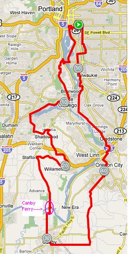
It was going to be yet another cold, clear, brilliantly sunny day. I was at her house at the appointed hour (drove over, sorry), with the Lemond, as the planned route is quite hilly, and Cecil was on her fast bike as well. Formerly Floyd and Little Pink Bear completed the group.
We worked our way to the Springwater Corridor, then south, then over the Sellwood Bridge (Cecil: "roadway or sidewalk?" Lynne: "roadway" Cecil: "of course"), then across Hwy 43 and up through the Riverview Cemetery. I was happy to have established on my ride DOWN through the cemetery the previous weekend, that it really wasn't all that steep - lots of switchbacks.
Then down Terwilliger into Lake Oswego - that was fun; practically no cars at all, then winching ourselves up out of downtown Lake Oz, westward around the lake itself (I only know this because the map tells me; we did not actually see the lake), out Bryant and Childs (or the other way around), and then Stafford and Johnson. And then, like practically every other ride I've done in the past two weeks, what group should come zooming by, but a bunch of Portland Velo racers! Again, waves and hellos. I wonder if they think we are all over the place as well?
Then onto Willamette Falls Drive, and familiarity with the next bit of the route; this is from the permanent we did in October. Today it was colder, but much drier and sunnier. Up Turner, then rolling along on Mountain Rd.
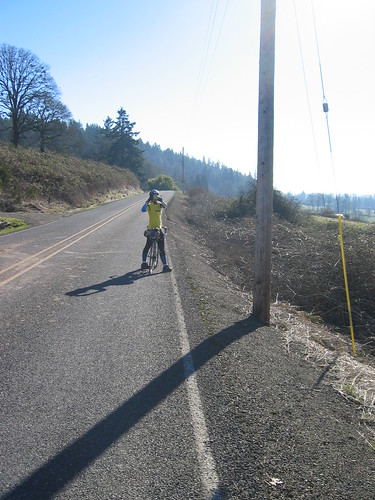
(it would not be a proper ride if we didn't take pictures of the other taking a picture)
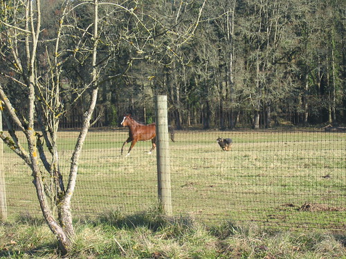
Heading to the Canby Ferry, we saw beautiful horses racing around a field. Then we saw the dogs and stopped to watch. The dogs were herding the horses around; for what purpose I do not know. They did have adult supervision, and it was fun to watch.
Then we arrived at the ferry. (See "Canby Ferry" on the map above) It was closed for MLK Day. Who knew? Or even thought? Of course, the gate at the TOP of the 17% grade road was not closed, nor was the Closed sign up. We stood there a bit and pondered options. Boone's Bridge over I-5 was discarded - it would add many more miles and complicated rerouting. We eventually decided to head back, and go over Pete's Mountain the other (harder, longer, steeper) way, then cross back over the river in West Linn, to Oregon City, at which point, we'd be back on the planned route.
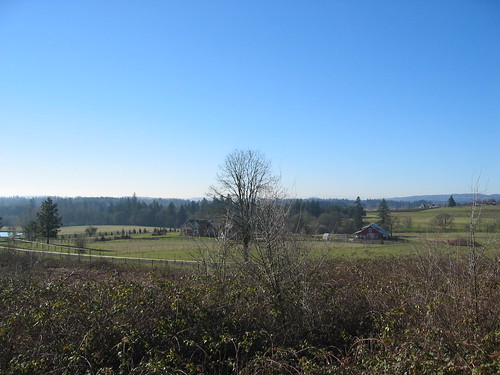
It is a good thing Pete's Mountain has fabulous views to the east:

Because there is lots of climbing. There is a vicious switchback just past the start, then, lots of up. And when you think you've summitted - surprise! This geographical wonder must have at least 10 false summits. About 7 false summits into it, Cecil pulled over. Her rear derailleur had checked out. After poking at it, with no success, she continued on. With the chain on the small sprocket in back, and her choice of three chainrings up front. That HAD to hurt. A lot.
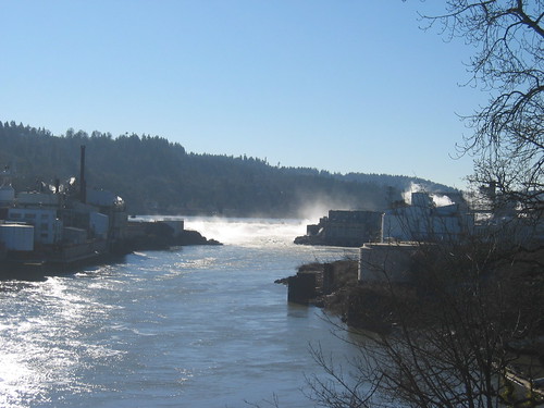
We finally turned onto Turner Rd to drop down to Willamette Falls Rd, which would take us right to the old Oregon City Bridge. I'd finally get a real picture of Willamette Falls, too. The roadway is really narrow (makes the Sellwood Bridge look like a 4-lane highway), so I walked out on the sidewalk and got my picture.

We had hoped to find the bike store open in Oregon City, first to effect a repair on Cecil's shifter, and second, to find a nut to put over the exposed bolt on my seatpost that kept grabbing my shorts every time I stopped. It was pretty funny. I had to remember to brake, move forward and THEN put my foot down. The whole ride.
Unfortunately, the store was closed, so we went over to the park next to the courthouse and had some snacks. After all that climbing, I needed fuel. The wind was whipping through, so we didn't stay long.
Then north, fortunately not with much of a headwind. We had enjoyed a nice tailwind all the way south. Cecil said there was a nicer way over the Clackamas River than the 99E bridge, and after a bit of searching, we found it - nice multipurpose paths on both sides of the river with a bridge. Then onto River Rd on the amazingly wide bike path (except on the steep hilly bit, right when you'd want it!), into Kellogg Creek Park, and eventually, finding a "Welcome to Portland" sign.
We decided to stop at the Hopworks Urban Brewery for a post-ride snack. Mmmm. Hummus, pita, and lots of hot coffee. Not that I was cold. Much.
But we were both cold for the last few blocks to Cecil's house, yes indeed. Cold wind, sun dropping. And then done. A nice ride. I think I've got a sunburn, too. In January. Who'd have thought?
57+ miles. 150+ miles for this three day weekend.

2 comments:
"With the chain on the small sprocket in back, and her choice of three chainrings up front. That HAD to hurt. A lot."
It hurt, but the pain passed quickly. And now I know that I can climb Pete's on my single-speed, if I have to :-)
Thank you for documenting your lovely ride. I live on Pete's Mountain and am working with other residents to preserve our community so that cyclists like you may continue to enjoy this rural area immediately accessible from Portland. Developers are lobbying to carve up Pete's Mountain to include high density housing, light industrial and commercial properties. This would change your cycling trips through our countryside permanently, as we would become a community like Gresham.
If you or your cycling colleagues could email us to tell how you cycle on Pete's Mountain or enjoy recreation in our area, it would help us build our argument that we should stay a rural buffer zone for people in urban areas to enjoy. Thank you. I recognized exactly where you were from the photos.
Christine, for the Petes Mountain Preservation Association
petesmountain@gmail.com
Post a Comment