That said, friend Susan suggested we ride Marcello's Bald Peak Permanent Populaire. 64 miles, 3000 vertical feet.
Weather was low 40's, maybe a teeny chance of rain. It did not say windy (insert foreshadowing music). I put some lube on Sweetpea's chain and called it good.
Met Susan at Marcello's just before 10am (it's only 100k. we had a leisurely start.). Marcello was going to ride as well. It turned out that Susan and I were the very first to ride this perm other than Marcello.
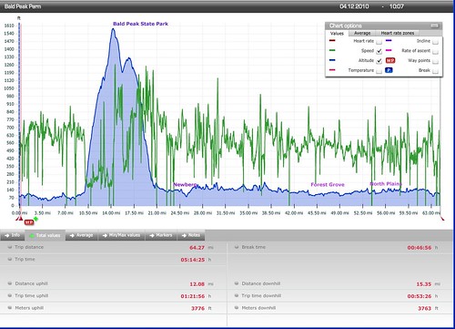
We took the standard "escape route" out to Laurel, but stayed on Bald Peak Rd rather than heading south to the store. Not so challenging right at the start, but just before mile 10, the road starting going up. Seriously up. The incline averaged 7% over 4.5 miles. It got to where I'd think "oh, this feels easy!", only to look down at the computer and notice that the incline had dropped below 10%. Found Susan about 1/3 of the way up. Ate my banana, Marcello came by (he rides a recumbent trike), and we pressed onward and upward.
At one point, I was hoping the grade would slack off as the summit got closer, but then I'd turn a corner and see another wall. One more very brief pause, and then the last mile. Found Susan at the park. Total climb time was about 50 minutes. Susan was cold, so we only lingered long enough for me to write down the info control answer and pull my jacket back on. Marcello came by and we all set out.
Now we were headed along the summit ridge, with the wind roaring in from the east and, to our west... air. Susan and I both hugged the center line, for fear of getting blown over ! Eventually we dropped below the ridge, but the descent did not let up. The only other time I have climbed Bald Peak was by the route we were now descending. Whacking steep. Turned onto Chehalem Drive - more hairpin turns and bits of gravel. Finally the grade slacked off, and I found Susan and Marcello at the intersection with North Valley Rd.
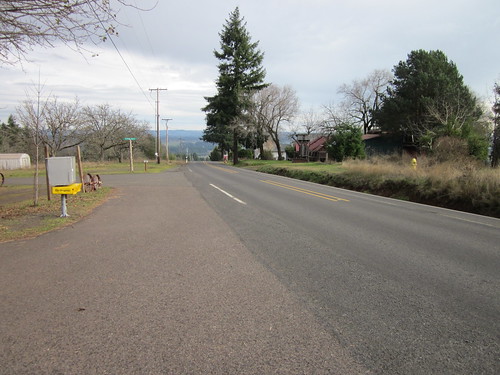
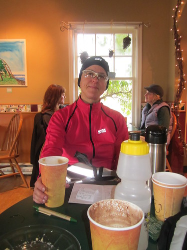
We all headed into Newberg. Susan wanted coffee and plumbing, so we elected to head over to the Coffee Cottage ("time sucking vortex"). Our receipts (allowing for that their cash register was still on daylight time) had us there right at closing of the control. If you do this ride, keep that in mind - no faffing between the start and Newberg :-)
We misplaced Marcello at this point, and didn't see him until we finished.
I had a mocha, and we shared a scone. The cheery young barista wanted to know if I wanted whipped cream on top - yes indeed, I need all the calories today that I can get :-)
Back out to North Valley Road, where we had a nice push westward and discussed the joys of surfing the rollers on a tandem. We've both done it, and the rollers are spaced just right.
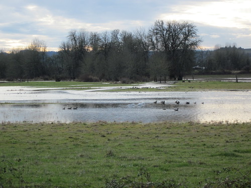
Then we turned north. The wind was still blowing hard from the east and north; there were many miles of it work our way through. The scenery on North Valley / Spring Hill is amazing as always. The wetlands are full. Susan's friends Catherine and Rick were out in their driveway near Gaston, so we stopped to chat. I was looking at the ridge waaaaaaay up there behind their house. That was the Bald Peak Ridge. Looks very steep from below. I ate a couple of Sweet Salty Peanut bars while riding along.
Brief pause just before the Fern Hill turn to get wetlands pictures, then north through Forest Grove.
The eastward stretch on Cornelius-Schefflin was tough. Susan's comment after the turn onto Gordon - "well THAT sucked". Into North Plains for a brief stop at the store for a receipt (and some sunflower seed kernels). Another eastward stretch on West Union to Helvetia - strong headwind and rolling. I kept looking for the school zone sign that signaled our turn to the south.
Finally, south on Helvetia, across Hwy 26, onto Huffman, then south on 229th/231st to Cornelius Pass. We had a quartering tailwind. Whew. Then the last bit east on Baseline, and a stop at the gas station for our ending receipt.
6:19 elapsed time, with, according to my bike computer, 45 minutes of not riding. Average of 12.26 mph. The temperature was mostly in the low 40's. No rain to speak of. I did not eat or drink enough. I really need to keep eating and not worry quite so much about keeping up with other people, because then I haven't eaten and I can't keep up!
After which, Susan and I went to our respective homes and cleaned up, Susan found us a restaurant downtown, and we all enjoyed eating at Mandarin House before all going off to listen to Target for Tomorrow and the Cherry Poppin' Daddies.

9 comments:
Nice chart. What's the computer/software combination that generated the data and view?
Hi Paul - Sigma Rox 9.0. The software is included with the bike computer.
Great ride. Of course, it's always windier at the top -- and coming back down. (I think I prefer my nutella waffle to your scone, though.)
Congrats! Are you doing an R-12 again or are you taking a rando break for the winter?
I won't say I'm doing an R-12 until I'm much further into it :-) I do not understand this winter break thing. There's flat permanents available for winter.
It was equivalently windy all over the route. Just that the top had a cliff-like aspect to the edge. Other roads we'd just get blown into the ditch.
Hi Lynne,
Have just connected with your blog. Interesting posts- will continue to follow.
Greetings from the UK
Trevor.
Please don't ride North Valley Rd
I drive this daily to work( forest Grove) and home(Newberg). It is 55mph and has many blind corners. This road is Yamhill county's highest through put road and it literally has zero shoulder in places.
I have nearly taken a life on this road coming around a blind corner and finding bikes in the center of the lane. I drive consistently at 45-50mph watching very close for farm equipment, deer and the many elderly that putt up and down the road. I have also personally witnessed a cyclist being scraped off the road into a body bag Near the most beautiful wetlands Reserve. It's sad. And I know statistics show this road has taken many cyclists lives since it was listed as a good bike route.
Please don't put us in the position of possibly taking a life on our commute home. I know I wouldn't drive my car on a train track or airstrip because it's not designed for cars and it's unsafe. If you decide otherwise, write a nice note to your family and to the poor victim who has to live with the memory of accidentally killing a cyclist. and listen for cars. If they are coming up behind and you are on a corner, hop off the bike and get in the ditch. People drive this road like nascar racers on North Valley. I can personally attest to that and gripe about it all day.
Thank you for considering
People riding bicycles have every right to use any road where they are not specifically prohibited (usually interstate freeways).
Where would you PREFER we ride? Hwy 47? I think not. Over Bald Peak? Noooo, I don't think so. It is a beautiful road.
People riding bicycles are not in the middle of the road. They might be out some feet from the right IN THE LANE. You, as a driver have a RESPONSIBILITY to not hit anything in front of you. Slow down, and wait until you have a clear line of sight, and then change lanes to pass. It won't delay you as much as you think.
And I'm not going to hop in a ditch.
And this ""to the poor victim who has to live with the memory of accidentally killing a cyclist".
There is nothing ACCIDENTAL about it. The driver made a CHOICE to drive in an out of control manner. One drives RESPONSIBLY.
Post a Comment