Put out a call for riding companions. Susan joined up, and suggested Marcello's Nestucca Rivers 210km permanent. Basically, Reach the Beach until the turn to go to Pacific City - go right, through Hebo, Beaver, and Blaine, over, and back down to Carlton and thence returning to Newberg. How hard could it be?
Susan was on a mission. She's got a ride in August she's planning on, so she's working on not wasting time. I am a champion time-waster. I was allotted three short stops - Willamina, Beaver, and Carlton. Ok, then. I've done STP in a day twice. It isn't like I don't know HOW to be efficient :-)
Weather was going to s*ck. 90% chance of rain, and we were riding through the Coast Range twice. The only good thing was that it wasn't meant to get too cold - mid 40's maybe.
Clothing selected and packed (2 extra pairs of gloves, dry socks, dry baselayer, nylon vest). Food prepared. Chain wiped off and fresh lube applied. Tires pumped up. Little Pink Bear (freshly washed) reinstalled.
Met in the Newberg public parking lot (traditional rando departure point). Susan was heading over to the Thriftway; I would be right behind her. Heard a big thump-bang sound, but couldn't see what it was. When I got to Thriftway, Susan was contemplating not riding. That sound was her going down on the very wet tracks. I decided to not say anything, and go get my banana and starting receipt. She elected to ride. Which was good, because the way the sky was dumping rain on us, I wouldn't have needed much of an excuse to DNS.
The ride west was pretty uneventful. Headwind, of course, lots of rain, a brief pause to get the answer to the info control in Ballston. On the road between Dayton and Amity Susan said: "I've got to design a route that does not use this road". Laudable goal. It does rank up there for the most boring stretch ever. Well, not Peoria Road or Buena Vista boring. But pretty close to Timber Rd from Hwy 26 to Vernonia boring.
Finally into Willamina. Note: the Center Market in Willamina will not let you use their bathroom, even if you are buying something, unlike the friendly folks in Dayton. We went to the grocery. Ate one of my sandwiches (I'd eaten a bar and some other stuff enroute), refilled one bottle with a Starbucks Doubleshot and topped off the water.
Through Willamina, under the highway, and onto Little Yamhill Rd. Such a nice road. Quiet. Wonderful pavement. The only question - how were we going to get across Hwy 18/22? Going east, it is easy. West, not so much.
We went over the overpass, and took the now dead-end road that loops behind the gas station and restaurant at Fort Hill that are no longer accessible, then portaged our bikes over the jersey barriers to the shoulder of the highway. As the barriers are pretty tall, if there is just one of you, probably better to get onto the highway from the overpass.
West until Grand Ronde road, where the climbing started (and the wind finally became more of a crosswind). Still raining.
The climb up to Sourgrass Summit was gentle and uneventful. I could see Susan up ahead from time to time when the road was less curvy. The rain lightened up a bit, but after summiting (no Susan), it returned. Or course, after summiting I descended into fairy-tale forest - trees finally leafing out for spring and very bright green moss on the trees. Down to Dolph Junction, the split where left would go to Pacific City (not today) and right would go to Hebo. New road for me here. I had been to Hebo once, a very long time ago. All I remember was rain. Nothing had changed in that aspect :-)
Rain, rain, rain, rain. Eventually I found Susan, and we pressed on. I really wasn't cold, and really not wet. My gloves were sopping, but my hands were warm. Feet were still not wet. A first. Intersected Hwy 101 at Hebo, and headed north to Beaver. Not much traffic. Second stop of the day (and first timed control) at 74 miles. Another Doubleshot for the bottle, more water, and a nice well-buttered Rye Molasses muffin. We had over two hours in the bank.
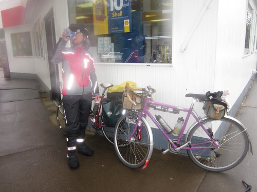
Susan: "13 minutes. Gotta go!" Yes, Drill Sergeant Susie. Then, as I was flipping my cue sheet... "Oh, you've got it printed in old-lady font!". With all due respect and affection... "F*&# you!" (channeling Jason here.) Okay then.

Picture by Susan Otcenas
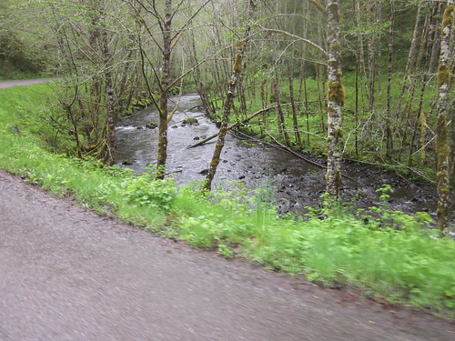
Still raining. Off to climb the Coast Range a second time. After the turn onto Upper Nestucca Rd at Blaine, we'd be on that road for about 40 miles, until we got to Carlton. It was very pretty. The rain eventually let up, and we even had bits of sunshine. We followed the river all the way up - a reasonably gentle climb for most of it. Up. Up. Up. I didn't know where the summit was. Up.
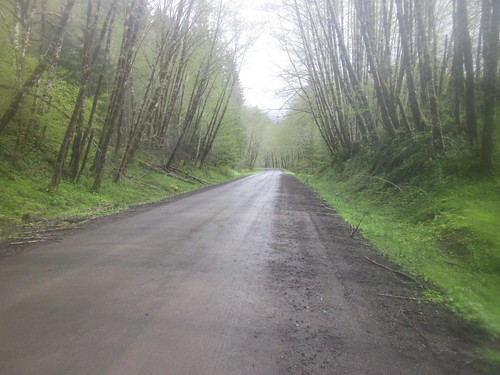
Then the pavement ended. I knew it was going to do that. Pretty hard pack, but it had been raining for 5 or 6 months straight, so it was perhaps a bit slick. Not bad going up, but when it started down (not to be confused with the summit, or finishing climbing), it was a bit challenging. So, pavement ends somewhere between 93 and 94 miles, and goes on for 2.5 miles. I saw Susan from time to time, but not much.
Up. Up. Passed several campgrounds. Up. Passed Dovre Campground, which I have actually heard of. Up. Found Susan. "This climb is NEVER going to end". That was my thought as well. I passed the time reliving Aerin's climb in The Hero and the Crown. All I needed was my sword, and I'd be set.
Several false summits later, including a nasty pitch by the reservoir (Lynne stops to recompose), I found Susan again. She was peeling off all her wet clothing and changing into dry. I was actually fine. I had even ditched the sopping gloves and was wearing my mesh shortfingers with some wool gloves over them. The rain had let up. Summit is around 105 miles.
Then down. The road was nice, but quite wet and curvy. Then it got much less nice and no less steep. Being well acquainted with hitting a pothole at speed, I kept my speed way down. Then the road improved again, and got a little less steep. Then rolling. Blah. I was hoping at some point that I would end up in Carlton, as there were NO signs on the road that I was approaching anything! Finally out of the forest, into rolling farms and vineyards.
Then, glory, hallelujah, I could see the white building at the intersection in Carlton. Wobbled over to the gas station on the corner; it was closed. Started coasting through Carlton, and saw Susan's bike leaning up outside a store. I was shaking - not from cold. And it wasn't like I was not eating constantly. Bought some grapefruit juice and sucked it down. Only 11 miles to Newberg.
The cue sheet didn't say, exactly, but Main turns into Hendricks, which turns into Kuehne, at which point I knew exactly where I was. The juice started having an effect (the tailwind didn't hurt, either) along this stretch. Got a bit misplaced in Newberg, but I've done enough rides through there that I quickly got myself back to the Thriftway. Susan had been there a couple of minutes already.
132 miles, 11:20 elapsed time, 13.20 avg mph, 5800+ vertical feet. 1:15 off the bike.
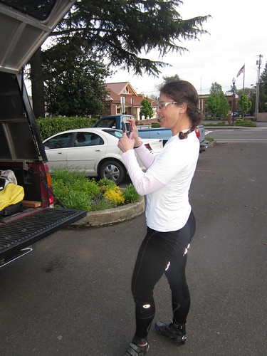

Picture by Susan Otcenas
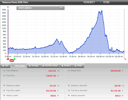
(the distance and time uphill are wrong)
Susan: "I didn't want an EASY 200". I'd recommend this one for summer - nice and cool when it is too hot in the valley!
Props to Susan for doing a very challenging ride after crashing on the tracks! She had a headache the whole ride, and was working on some very nasty bruises.
Another banana and a receipt, whereupon we returned to the cars and adjourned to Burgerville. Dry clothes, cheeseburger, fries and a Timber Joey milkshake.

2 comments:
I've only done that second climb in the pitch dark (between 2 and 4 AM). Sometimes it helps not to be able to see how steep and neverending it is.
I was wondering if that was the road. The descent to Carlton in the dark would be freaking scary.
Post a Comment