There were people registered that I could have conceivably ridden with. They weren't at the start on the bright, sunny (UNSEASONABLE!!!) Saturday morning. Chris W offered to tow me :-) Visited around, and got a room key from Michal. He had offered up their room floor, because driving home after a 300k has been chancy.
Did I mention that the weather was unseasonably excellent? Sun, 60's, clear, almost full moon. Light winds. Amazing.
We started out at 7am, and the pack rapidly sorted itself out (everyone passing me). Eventually I fell in with Kevin. Sadly, he was only riding the 200k.
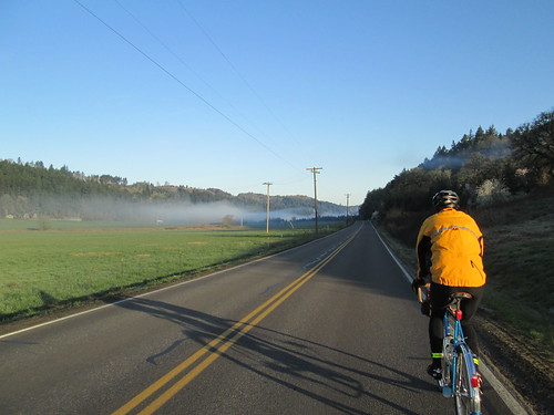
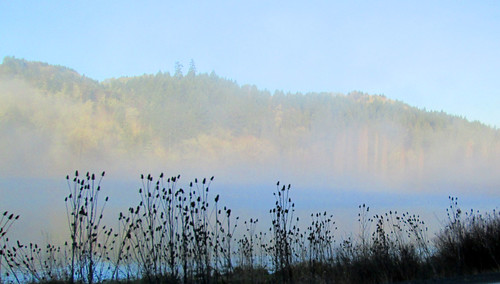
Wonderful fog on North Valley Rd, just enough to snap some pictures, but not enough to be annoying.
Aside: I had thought to finish between midnight and 1am. Michal helpfully created and sent me a schedule, with a "this will work if you maintain a 13mph average". Mmm. The first loop had a whacking steep 8 mile climb towards the end. Well, I'd certainly give it a go.
We arrived at Maggie's Buns (first control, in Forest Grove), to find Keith K outside signing cards, because "it is a zoo in there". Indeed it was, so I had him sign my card, and relieved another rider of the necessity to eat the entire sticky bun he was carrying around.
Kevin and I then set out again, ahead of (my) schedule. We got as far as the golf course, where he decided to pull over, and I went on. Caught up with the only other woman riding (Robyn, riding the 200k) for a bit, then we split up.
Made it to Sherwood, and Sesame Donuts, without incident. No other riders around. I got a bagel with cream cheese, ate half, and saved the other half for later. Off to that climb. The route took us through neighborhoods and a bike path, and, after crossing Hwy 99, the climb started.
I've ridden it several times before, but the last time was Feb 2011 :-) The climb goes up Kruger, Leander, and Chapman roads, to the Gibbs Cemetery, and, for extra vertical feet this time, continued along Mountain Top Rd, for an info control at Neill Rd.
Where, as I suspected, I found Susan F and some stickers. She lives right up there. Keith K and Tomas were also there, So I got to ask Tomas about a Ride With GPS feature, and chat about cue sheet text with Keith and Susan.
Next up, the 5 mile drop to Newberg. It was on Hwy 219, so I pulled over a couple of times to let some cars get by, but I was otherwise completely enjoying the descent.
I didn't stop in Newberg. I figured I could get what I wanted in Lafayette, which had a c-store and would be a much quicker stop. Ate the second half of that bagel along the way. Because of the climb, I was now 30 minutes behind. Maybe I'd make it up on the next two loops.
Or not. Last time I rode this, it was gray and gloomy and chilly and February, and I started "hearing the banjos", as Cecil puts it. It was all nice and sunny and warm, and I wasn't hearing banjos.

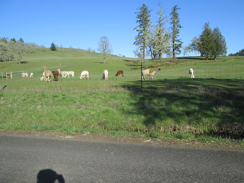
However, I'd completely forgotten about all the steep little lumpy bits from the Westside Hwy all the way to the Sheridan Dairy Queen. And the bugs. Lots of bugs! Yellow ladybugs, and some other winged pest. On the bright side, the fluffy, adorable Pucara Alpacas were all out in their field. So I didn't make up any time, but I didn't lose any, either.
There were a few cyclists in the Dairy Queen, as well as many other people. But it turned out they were just standing around, so I ordered a kid's chicken strips meal. I got the dessert first (butterscotch Dilly Bar), which I consumed while waiting. Greg P was there, looking kind of toasted. He asked after Kevin, but I hadn't seen him since we parted ways at the golf course.
Now headed back to Newberg, to finish off loop 2, and change my shoes. I was wearing new ones, and I really wanted them to work. But they weren't. :-( I'll have to see if I can return them. I was not ENTIRELY stupid; I had my winter boots and sandals in the car, which I could visit every 100k.
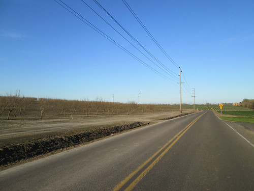
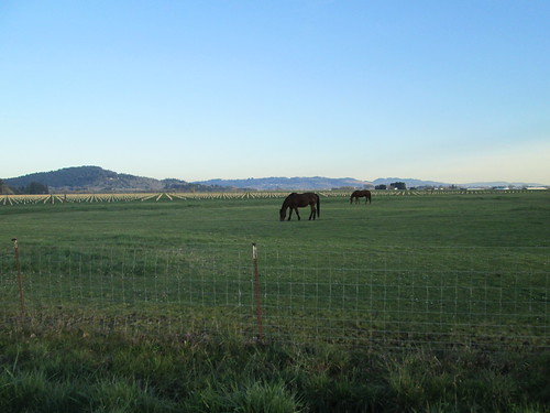
The route back went through the countryside north of Amity; lots of roads I am not familiar with until intersecting 233 outside of Dayton. Lots of fields with rows, some horses, and a big, silent chaser dog that I didn't even see or hear until the owner called it off. (!) Not even jingling collar tags!
Got to Dayton. I had planned to stop at the Center Market; needed my V-8, more water and a banana. Parked outside were two incredibly cute Brownie Girl Scouts, hawking cookies. If only I'd had room to carry them... We did visit a bit while I sucked down the V-8. They are cookie-selling rockstars, 900 boxes each. Speaking as a former Girl Scout Leader, I can tell you that is amazing. Especially in Dayton. I am not sure 900 people live there! The leader mentioned that another rider had been through a few hours ago, wondering about the route (Kreder Rd? Where was that?). She said "he was going to Newberg by a really stupid route". Indeed, so was I. Exact same stupid route, except I knew that Kreder Rd was accessed by a footbridge over the river after a tiny bit of off-road riding.
So, only 9 or so miles to Newberg. I wasn't expecting any problems or delays. Gah. The traffic was way backed up into and through Dundee, and I couldn't scoot by on the shoulder because ODOT had repaved 99W (yeah!), but made the shoulder MUCH narrower (boo!), so the giant enormous Safeway semi was blocking. I couldn't get around it, for fear it wouldn't see me.
So, that sorted, I got into Newberg, and it was getting dark. Now, I can reliably navigate myself to the Thriftway, the public parking lot, and the Burgerville, but the route was a bit past that. Hard to read the street signs, so a bit of a navigational pause. But I did get to my car, swap out my shoes (toes/forefoot breathe HUGE sigh of relief), and go off in search of the Circle K for my open control receipt. They assured me they were open 24/7.
So, full dark now, and somewhat later than I wanted to be starting the last loop. I still had plenty of time, and the last loop had absolutely NO demanding territory. As I was making the second turn onto Champoeg Rd, a whole peloton of randos came the other way. We exchanged hellos and continued on. I'd run into 4 or so more groups headed back. Leaving Gervais, after a stop to pull on another layer, I saw Michal and another rider heading in. Those would be the last riders I'd see; the loop had a lollipop through Silverton.
The stars were quite bright, and the moon was up, but not quite bright enough to cast a shadow.
Got into Silverton, and discovered my phone was completely dead. I stopped at the first food place on the way in - no, they had no more soup and could only provide fried food. Kept on. There is allegedly a Subway in Silverton, and it was supposed to be open, but I didn't see it. Last chance, the Oak St Market, at the top of hill. They were open. I elected to get a Red Bull, and eat/drink the food in my bag.
The route out of Silverton was familiar. I could even picture it in my head, since it was dark :-) At least until 114th St. My bike computer was tracking nicely with the cue sheet, and here was a road in the middle of nowhere, sadly without a street sign. There was indicated to be another turn a bit further along, so I went with it, and found a "114th St" sign there. And then it turned into Waypark, at which point I no longer actually needed the cue sheet, except to reassure myself as to how far I had left to ride.
By now you might have suspected I was riding solo, in the full dark, in somewhat rural territory. It was great! I had the roads ALL TO MYSELF, but for the extremely occasional vehicle, all of which passed me with plenty of room. I had my iPod in my bag, but never felt the need to get it out. So, yeah, at this point, I am over the stressing over riding around all by myself in the dark thing.
Through Gervais (store closed, it was 12:30am), then mindlessly north. Past Champoeg Park. Over the Willamette River. Happy it was dark and I couldn't see off to the sides, because I still don't like crossing the river on Hwy 219. Not that it mattered, because no one was on the road but one stupid randonneuse.
Into Newberg, looking for some place to get the finish receipt. I started heading west on Hwy 99 toward the Circle K, but saw the Open sign at an expedient food establishment. Went to turn into the driveway and bam! Not quite the driveway. However, the parking lot was full of extremely courteous college students, who dusted me off and made sure I was ok. I was, but for my pride.
By now it was Daylight Savings Time and 3:15am. The cashier wrote 2:15 PST on my card. (The RBA was also watching my SPOT; she knew when I'd finish). Sat down with a lemonade. I really didn't want to eat anything by now. Whew. Done.
No sleepies. No low points.
Rode back up to my car, loaded up the bike, and drove around the block to the motel. Shower. Sleep. After breakfast the next morning, came home, ate a bit, and took another very long nap.
All the pictures.

2 comments:
As you've guessed, I was the randonneur who asked the girl scouts and attending adults about the route to Kreder. Couldn't figure out the cue sheet there ... it said "turn right" but didn't say onto what; I took the right where the pavement ended, and that wasn't the right right.
Again, it looks like the Final cue sheet was updated after it was pronounced Final, but no statement was given to that effect.
Post a Comment